Table of Contents
Basic of Plane Table Surveying
Plane table surveying is the field and graphical method of surveying. It is the fastest ,easy and cheapest method of surveying in which field observation and plotting are done simultaneously.
This method is generally used in small scale or medium scale flat areas. It is used to plot topographic features in full scale view.
If surveying land is flat and there is no any obstacles and if you required fast results, then plan table surveying is best suitable method.
One disadvantages of plane table surveying is that it gives less accuracy compared to other methods of surveying.
Principle of Plane Table Surveying
Main principle of plane table surveying is Parallelism. Parallelism means all the rays drawn during plotting of map should be always parallel to actual ground lines from station point to object point and all the rays should pass through the survey station.
In this method, surveyor observe and plot the position of object points on drawing sheet which is placed on drawing board. After that surveyor measures distance and angles and then relative position of that object points can be determined.
Objectives of Plane Table Surveying
Main objectives of plane table surveying are :
- To prepare small scale maps
- To locate the topographical features
- To carry out small scale surveying very quickly
- To compare the plotted work with the actual features of the area surveyed
- To measures distance and angles between different object points and then relative position of that object points can be determined.
- To establish control points for future surveys
Equipment and Accessories used in plane table surveying
In plane table surveying following equipment and accessories are used :

1. The plane table
- Traverse table : It consists tripod and drawing board mounted on it. Drawing board can rotated about vertical axis and can be clamped at any position. By tripod you can level the table.
- Johnson table : It consists ball and socket joint between drawing board and tripod and two thumb screw underside. This thumb screw and ball and socket joint used to rotate and level the table.
- Coast survey table : This table is used for very accurate working. It consists foot screw, tangent screw and clams which are used for accurate levelling of table.
| Drawing Board | Sizes |
|---|---|
| B0 | 1000 ✕ 1500 |
| B1 | 700 ✕ 1000 |
| B2 | 500 ✕ 700 |
| B3 | 350 ✕ 500 |
2. Alidade
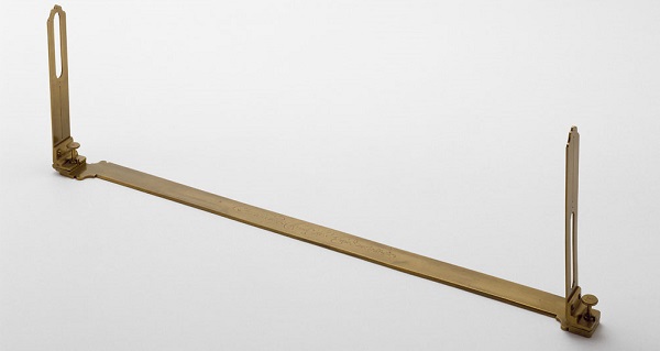
It is used to bisect the object, draw direction lines, draw rays. It is simply a ruler with a sight line attached.
A. Plain alidade : It is a wooden or a metal rectangular block fitted with two sight vanes and straight edge or ruler about 50cm long. The welled edge of the alidade is called the fiducially edge.

- Eye Vane : It consists three equally spaced split holes for bisecting.
- Object Vane : It consists thin wire or hair which is stretched between the top and bottom.
This two vane can be folded so, if we not using, it can be folded.
B. Telescopic alidade : It consists a telescope with a level tube and graduated arc mounted on horizontal axis. It is used when it is required to take inclined sights. It gives higher accuracy and more range of sights.
A small spirit level tube is provided with the telescope so that it can be leveled with the working station.
3. Spirit level
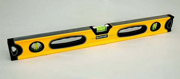
Spirit level is used to level the table or fix the table horizontally. It is placed on the drawing board in two perpendicular direction. When bubble is at its center position, the plane table is levelled.
It is also known as level tube. It is either tubular or circular.

4. Plumbing fork
A plumbing fork is a U-shaped brass frame made of arms of equal length.
A plumb bob attached with it at its one end which is used for centering the plane table at a particular station and for Transferring of ground point. And other end of plumbing fork is kept over the drawing sheet.
5. Trough compass
A trough compass is a type of magnetic compass that is used to accurately align a plane table to the magnetic north-south direction.
A trough compass is also used to orient the plane table with respect to the magnetic meridian.
A trough compass consists of a long, narrow rectangular box(15 cm long), covered with glass. Inside the box, at its center, there is a magnetic needle resting on the pivot. There are also graduated scales with zero at the center and marking up to 5° on either side of the zero lines.
The Trough Compass is placed on a plane table which is to be aligned to the magnetic north-south direction. Then surveyor starts rotating the compass horizontally very carefully until the magnetic needle of the compass aligns with 0° on the graduation scale, thus aligning the plane table with the magnetic north.
6. Tripod
A tripod is a portable three-legged frame or stand, used as a platform for supporting the plane table.
It is made from wooden or aluminium materials.
We can level the plane table by smooth moving of tripod legs and by using spirit level or level tube.
7. Drawing Paper
The drawing paper used for plane table surveying must be of superior quality so that it can not change with humidity of atmosphere and it should withstand rubbing and scrubbing.
A drawing sheet is fixed on to the top of the table, the observations are made to the objects, distances are scaled down and the objects are plotted in the field itself.
8. Other accessories
- Water proof cover
- Ranging rods
- Plumb bob
- Tape
- Chain
- Paper clips or screws
- Other accessories for drawing
Working operation of plane table surveying
Working operations are performed to make the instrument ready for making observations efficiently.
There are three working operation of plane table surveying.
- Fixing the plane table
- Setting up the plane table
- Sighting the points
1. Fixing the plane table
In this process plane table is fixed on the tripod stand. Arrange the drawing sheet on the plane table and attach it with plane table using paper clips or thumb screws so that it can not move during the working operation. The sheet should be in one position from first to last.
2. Setting up the plane table
Three simple, easy steps can do the setup of a plane table survey instrument.
A. Levelling of plane table
B. Centering of plane table
C. Orientation of plane table
A. Levelling of plane table
Levelling is the operation of bringing the plane table in a level position with earth or a horizontal position.
We can level the plane table by using spirit level or level tube and by smooth moving of tripod legs.
Spirit level is placed on the plane table in two perpendicular direction. When bubble is at its center position, the plane table is levelled.
Also adjust the working height of plane table during levelling process, so we can do work easily.
There are three methods used for levelling operation.
- Ordinary tilting the board
- By adjusting the legs of the tripod
- By ball and socket arrangement
B. Centering of plane table
Centering is the process where the plotted station should be fixed accurately over the ground station.
The operation of centering is carried out by means of U-frame or plumbing fork and plumb bob.
A plumb bob attached with plumbing fork at its one end which is used for centering the plane table at a particular station and other end of plumbing fork is kept over the drawing sheet.
In case of small scale drawing small error is permissible in centering. But for large scale drawing very accurate centering should be done.
C. Orientation of plane table
In case of using more than one instrument stations, orientation is required. Every time the table is moved the new station should be parallel to the previous station. So the line of the map can be drawn on the drawing sheet parallel to other stations.
There are two methods of orientation that are commonly used.
- Orientation by through compass : In this process turn the table clockwise or anticlockwise until the needle coincides exactly with the 0-0 mark of the compass. While turning the table, take care that it should not disturb the centering. This method is used for rapid approximate orientation. It gives less accuracy.
- Orientation by back sighting : This method is always accurate and it is always preferred. In this method, a particular line drawn from the previous station is drawn again from the new station by using alidade.
3. Sighting the points
Once the plane table has been set, i.e. levelling, centering and orientation of plane table is done, the points to be located are sighted by using alidade and rays are drawn on the drawing sheet.
Methods of plane table surveying
There are 4 methods which are used in plane table surveying, Radiation method, Intersection method, Traversing method and Resection method. Let’s discuss all in detail below.
1. Radiation method of plane table surveying
- In the radiation method, instrument is set up at a single station point, from where all the details should be clearly visible which are to be plotted. Then rays are drawn from the instrument station to the points which are to be plotted.
- Then distance between various points and the instrument’s station is measured with a tape or chain.
- After that, by suitable scale, the distance is plotted in the drawing sheet.
- This method is generally suitable for small scale areas where distances are small and can be measured with a chain or a tape.
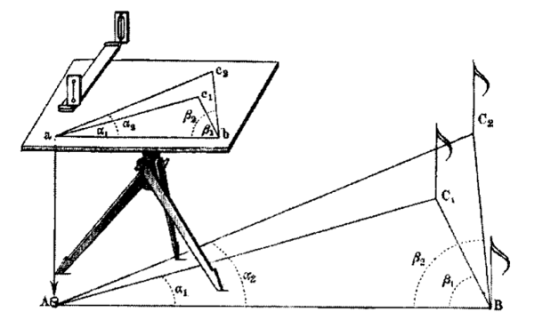
2. Intersection method of plane table surveying
- Intersection method is mostly useful where it is not possible to measure the distances on ground like obstruction of rivers or a mountains. Hence, this method is used for locating inaccessible points.
- In this method two station points are selected from where third station is visible.
- Then set instrument at both the stations and draw rays by bisecting the 3rd station.
- The intersection of these two rays gives the third station on drawing sheet.
- By using scale, we can measure the distance from 3rd station.
- For checking the accuracy of work, measure the distance from 3rd point on ground and compare it with its length on the paper.
3. Traversing method of plane table surveying
- Traversing method of plane table surveying is generally used to plot a traverse. In this method, first of all traverse stations are selected. Then all stations are plotted by radiation method by taking back sight on the previous station and a fore sight to the following station.
- In this method, distances are generally measured by chain or a tape with great care.
- This method is mostly suitable for a survey work of a narrow strip of the terrain like roads, railways, etc.
- This method can be used for both open traverse as well as close traverses.
4. Resection method of plane table surveying
- Resection method of plane table surveying is generally used to locate and plot the position of the plane table during surveying. This is also used for the orientation of the plane table.
- The basic principle of resection method is opposite to the intersection method.
- In this method, the position of the plane table is determined by drawing rays from already known plotted points.
- There are different methods for locating plane table by method of resection, but we primarily use orientation method of the plane table.
Advantages of Plane Table Surveying
Some Advantages of Plane Table Surveying are given below.
- No great skill is required.
- Errors occurring due to mistakes in the field book entry are eliminated.
- Sighting and plotting are done simultaneously. So no office work required.
- The errors and mistakes in plotting can be checked by drawing check lines.
- It is the most rapid and useful method for plotting a map.
- It is used in the places where there is a high magnetic fluctuations where compass survey is not reliable.
- It is less costly in compare to other methods of surveying.
Disadvantages of Plane Table Surveying
Some Disadvantages of Plane Table Surveying are given below.
- Its accuracy is very less compare to other methods of surveying.
- This method is not suitable in raining and windy areas
- Plane table is very heavy to carry and the other accessories are very small, so there is a chance to be lost.
- This method is not suitable in foggy areas due to the lack of visibility.
- Also it is not suitable in undulating areas.
- This method is used only in the day time.
- This method is not suitable for working in a wet climate areas.
FAQs :
What is the principle of plane table surveying ?
Main principle of plane table surveying is Parallelism. Parallelism means all the rays drawn during plotting of map should be always parallel to actual ground lines from station point to object point and all the rays should pass through the survey station.
What are the objectives of plane table surveying ?
Main objectives of plane table surveying are To carry out small scale surveying very quickly, To measures distance and angles between different object points and then relative position of that object points can be determined, To locate the topographical features, To establish control points for future surveys etc.
What are the methods of plane table surveying ?
There are 4 methods in plane table surveying, Radiation method, Intersection method, Traversing method and Resection method.
What is radiation method of plane table surveying ?
In the radiation method, instrument is set up at a single station point, from where all the details should be clearly visible which are to be plotted. Then rays are drawn from the instrument station to the points which are to be plotted.
What is resection method of plane table surveying ?
Resection method of plane table surveying is generally used to locate and plot the position of the plane table during surveying. This is also used for the orientation of the plane table.
What is intersection method of plane table surveying ?
Intersection method is mostly useful where it is not possible to measure the distances on ground like obstruction of rivers or a mountains. Hence, this method is used for locating inaccessible points.
What is traversing method of plane table surveying ?
Traversing method of plane table surveying is generally used to plot a traverse. In this method, first of all traverse stations are selected. Then all stations are plotted by radiation method by taking back sight on the previous station and a fore sight to the following station.
Also Visit :
➤ Civil Engineering Study Materials
Download Our App
“Vlcinfo” is an Educational App where you will be able to find details about various Job Related Updates, Test Series, Results, Syllabus, Old Papers, Video Lectures, MCQs Practice and much more.

App Features :
- Job Related Updates
- Test Series
- Video Lectures
- Study Materials
- Current Affairs
- Old Papers
- MCQs Practice
